Boulder to Erie Regional Trail (BERT): Comment on Draft Plan
Written by the BCAS Conservation Committee
Your voice is needed to protect sensitive wildlife and habitats around White Rocks Nature Preserve and Sawhill Ponds Wildlife Preserve!
Please urge the County Commissioners to seek less ecologically harmful routes from Sawhill Ponds to the White Rocks trail.
PROJECT STATUS AND BACKGROUND
Boulder County, in partnership with the city of Boulder and the town of Erie, is evaluating options for the creation of the Boulder to Erie Regional Trail (BERT), a new soft-surface regional trail connection, about nine miles long, linking Boulder and Erie. The project team recently completed a master planning process, started in 2019, to identify needs, opportunities, and constraints. The Boulder County Board of Commissioners will decide on October 24 (see below for details) whether to accept the draft BERT Plan, which includes the preferred trail alignment, known as 1B, proposed by County staff.
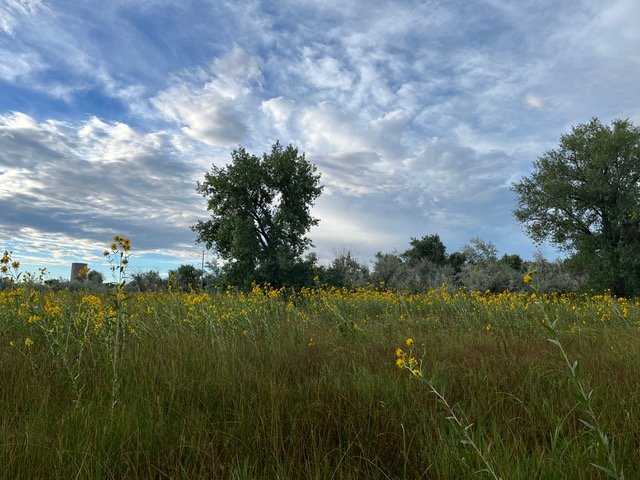
Looking towards a portion of County staff's proposed preferred BERT alignment 1B, through habitat for fireflies and monarch butterflies. Photo by Linda Andes-Georges.
BERT Plan DRAFT before the Boulder County Commissioners
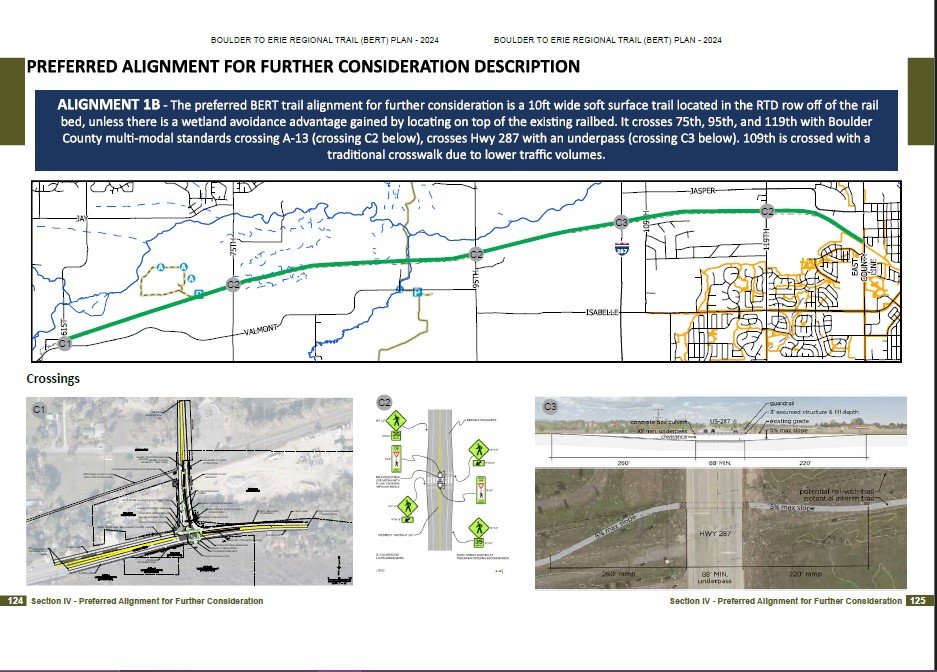
The BERT Plan DRAFT describes several conceptual alignments, and identifies alignment 1B as the preferred alignment, following the RTD rail right-of-way (formerly owned by Union Pacific Railroad). This alignment is very ecologically harmful, as demonstrated by tables, maps, and text in the Plan DRAFT. It goes through important wildlife habitats and ecosystems, including a Boulder Open Space and Mountain Parks Habitat Conservation Area at White Rocks and a number of valuable natural resources, designated in the Boulder County Comprehensive Plan, at both White Rocks and Sawhill Ponds.
BERT Preferred Alignment 1B, Plan pp. 124-125 (pdf p. 63)
The hearing will be held on the 3rd floor of the Boulder County Courthouse located at 1325 Pearl St. in Boulder.
With 3 days advance notice, help in another language is available. With 2 days advance notice, ADA accommodations are available.
Submit written comments to the Boulder County Board of Commissioners by emailing commissioners@bouldercounty.gov
NOTE: It is important to email your comments even if you plan to speak in person or virtually, so that the Commissioners have a chance to read your comments ahead of the meeting.
Make sure to reference the BERT and the Thursday October 24 meeting in your emailed comments.
Email your comments by Tuesday October 22 so the Commissioners have a chance to read them. The sooner the better!
Advocacy Points to Consider When You Prepare Your Comments
Your comments will likely be most effective when you use your own words. Below are some ideas to get you started.
THEME: Seek a less ecologically harmful route from Sawhill Ponds to the White Rocks trail
With increasing human population and encroachment on wildlife habitats in Boulder County and surrounding areas, it is critical to protect the best remaining habitats. For the BERT, we believe this means choosing a less ecologically harmful route from Sawhill Ponds to the White Rocks trail.
While recognizing the community desires and need for safer routes for bikes and other forms of recreation, and staff time already dedicated to the BERT planning process, it is worth taking time to seek an alternate alignment that provides for safety and visitor experience, without sacrificing sensitive and rare wildlife and ecosystems. A short-term delay for County staff to collaborate with Boulder Open Space and Mountain Parks (OSMP) staff is a good investment of time to help prevent long-term, and perhaps permanent, loss of irreplaceable wildlife, plants and ecosystems.
The BERT planning phase has evolved from several conceptual alignments to one preferred alignment in the RTD rail right-of-way (ROW). Preferred alignment 1B is a finite width along and adjacent to the former railroad tracks, and leaves little room for avoiding or mitigating for invaluable wildlife and habitats during future project phases. The proposed preferred alignment will alter the hydrology of areas along and near the trail, affecting plants and animals requiring moisture.
One option is a reconsideration of about 2.5 miles of conceptual alignment 2, using the north side of Valmont. This portion of Valmont is rural and scenic, with relatively few driveways and would avoid most of the raptor nest buffer areas, the OSMP Lower Boulder Creek Habitat Conservation Area, and Boulder County Comprehensive Plan-designated resources.
As the evaluation table on draft Plan pp. 114-115 (pdf p. 58) clearly shows, preferred alignment 1B is highly detrimental to ecological resources., including the following:
This alignment bisects the Lower Boulder Creek Habitat Conservation Area at White Rocks on Boulder OSMP property
This alignment would pass through a number of valuable natural resource areas designated in the Boulder County Comprehensive Plan Environmental Resources Element (ERE, see maps on pp. 71 and 72 of the Appendices) including:
Critical Wildlife Habitats
White Rocks/Gunbarrel Hill Environmental Conservation Area
A High Biodiversity Area
Significant Natural Communities
Rare Plant Areas
Wetlands
Riparian Areas
The area of highest concern is along approximately 2.5 miles of alignment 1b where it passes through OSMP land, from about one-half mile west of 75th Street, adjacent to Sawhill Ponds Wildlife Preserve, then east to the White Rocks trail, which runs north/south on the north side of Valmont, about 0.6 miles west of 95th St.
At Sawhill Ponds, Critical Wildlife Habitat protects numerous rare bird species, plus remnant tallgrass prairie, which supports breeding monarch butterflies and a robust population of fireflies.
At White Rocks, Critical Wildlife Habitat protects rare plant species, breeding northern leopard frogs, and breeding habitat for numerous bird species that are rare in Boulder County.
Alignment 1B includes areas where OSMP and Colorado Parks and Wildlife (CPW) biologists have recommended seasonal closures for up to nine months for nesting raptors and herons (see map on draft pan pp. 166-167, pdf p. 84 and CPW’s July 19, 2024 letter, updated on August 9, 2024 on pp. 560-563 of the Appendices). Some of these nests will likely move somewhat over time, but 23 nest territories, shown on the map on pp. 164-165 (pdf p. 83) of the draft plan, are not going away before BERT construction starts. OSMP manages lands to conform to, or exceed, CPW’s recommendations, and to maintain these standards would necessitate many months of closures annually. Proceeding with the preferred BERT alignment thus may generate conflict with OSMP’s land management practices.
Additional advocacy topics to consider for your comments:
Preserving the option for an overpass at Highway 287: Plan pp. 52-53 shows two options for crossing Highway 287 - an underpass at the RTD ROW crossing and a jog north to Boulder Creek to cross under 287. Crossing under Hwy 287 at Boulder Creek would raise concerns about disrupting the creek corridor for wildlife. In case the water table is too high at the RTD ROW crossing and an underpass is not feasible, it makes sense to leave an option for an overpass at Highway 287 at the RTD ROW on the table.
Nighttime Use: Other regional trails in Boulder County allow use 24/7. If nighttime use is allowed on the BERT, especially through sensitive areas, many wildlife species are likely to be affected - from white-tailed deer, bobcats and owls to foxes and fireflies. Nighttime use is not discussed in the Plan DRAFT, but should be evaluated during this planning phase. Use data from existing regional trails such as Coal Creek and LOBO, including night use, may provide valuable context.
Dogs: Dogs are not discussed in the draft plan. A substantial body of research shows that the presence of dogs, even on leash, disturbs wildlife. Consideration of whether to allow dogs on all or part of the BERT, and leash requirements, should be included in the draft plan.
Sunrise along the RTD Right-of-Way that would be converted for BERT. Photo by Linda Andes-Georges.


