Conservation Corner Updates
Written by the BCAS Conservation Committee
Boulder to Erie Regional Trail (BERT)
Boulder County, in partnership with the City of Boulder and Town of Erie, is evaluating options for the creation of the BERT, a new soft-surface regional trail connection, about nine miles long, linking the City of Boulder and Erie. The project team is conducting a master planning process to identify needs, opportunities, and constraints of constructing the BERT. That process began in the spring of 2019 and is nearly final. The Boulder County Board of Commissioners will make a decision on whether to accept the BERT Final Master Plan on October 10 (additional details below).
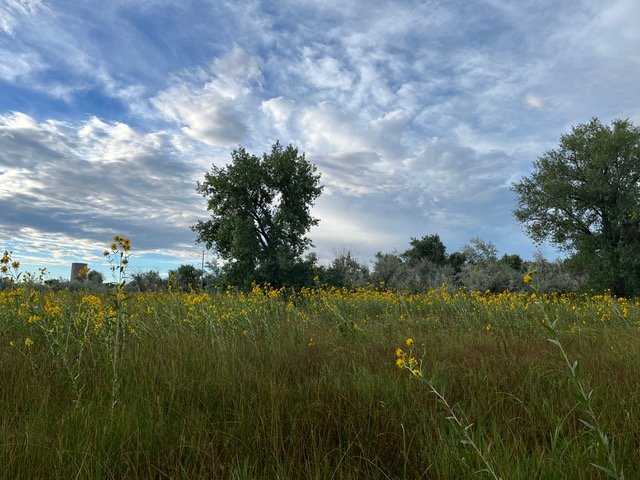
Looking towards a proposed location of BERT through habitat for fireflies and monarchs. Photo by Linda Andes-Georges.
The draft of the Final Master Plan describes several conceptual alignments, and a Preferred Alignment following the RTD right-of-way (formerly owned by Union Pacific Railroad). This alignment is the most environmentally harmful of the conceptual alignments, as it goes through important wildlife habitats and ecosystems, including a Boulder Open Space and Mountain Parks Habitat Conservation Area and a number of valuable natural resources designated in the Boulder County Comprehensive Plan.
View the draft BERT Final Master Plan and upcoming public comment opportunities on the Boulder County BERT webpage here. (NOTE: The appendices were not yet posted at the time of writing. ) Click here for other project documents.
What You Can Do
Comment to the City of Boulder Open Space Board of Trustees in writing, in person, and/or over Zoom for their meeting Wednesday, September 11 at 6:00 PM. Support Boulder Open Space and Mountain Parks staff recommendations on pdf p. 25 and Colorado Parks and Wildlife recommendations in their July 19, 2024 letter on pp. 41-44 of the agenda packet.
Submit comments online during the BERT plan public comment period September 5-25
Comment in person or over Zoom to the Parks and Open Space Advisory Committee (they will see written comments submitted by September 25) at their meeting on Thursday, September 26 at 6:30 PM.
Comment in person or over Zoom to the Boulder County Board of Commissioners (they will see written comments submitted by September 25) at their meeting on Thursday, October 10 from 1-4 PM.

Sunset along the RTD right of way that would be converted for BERT. Photo by Linda Andes-Georges.
North Foothills Bikeway
Boulder County is conducting the North Foothills Bikeway Feasibility Study to determine the feasibility of a bikeway along US. 36/North Foothills Highway that is separated from motorized vehicle traffic. The study is looking at the 11 miles between the City of Boulder and the Town of Lyons. The study focuses on land that is within CDOT right-of-way. The Boulder County Transportation Planning Division is working with CDOT, County Parks and Open Space, the City of Boulder, and the Town of Lyons on the study.
The purpose of the bikeway is to improve safety and comfort for cyclists of all ages.
Comments may be needed regarding protection of natural resources - stay tuned!
Learn more and sign up for project updates on the Boulder County website here.
Hwy 36 Wildlife Crossings
Boulder County is in the process of planning wildlife crossing structures along US 36 between Boulder and Lyons, to help reduce collisions between vehicles and wildlife, and make it easier for animals to move around the area. The project is still in its early planning phases and public input, including input from nearby property owners, will be requested and used as the project progresses.
Project lead Susan Spaulding, Boulder County Parks and Open Space Environmental Resources Specialist, is the speaker for the October BCAS program.
Learn more about this project and wildlife crossings in general, sign up for email updates, and take a short survey on the Boulder County website here.
NOCO Places
Earlier this year, BCAS became a partner in NOCO Places, a coalition of eight county, state, and federal public land agencies from north-central Colorado that are actively collaborating to address the challenges the mountains and foothills in this region are facing from high visitation and a growing population. See the member agencies list, mission statement, goals, partners, core principles and more here. NOCO Places is one of a number of Regional Partnerships around Colorado that are part of Colorado Parks and Wildlife’s (CPW) Regional Partnership Program, established by Governor Polis in 2020 and provides funding sources for the coalitions.
NOCO Places’ latest accomplishment in working with tourism partners to distribute common messaging about land stewardship and safety to Colorado visitors is development of an interactive story map that provides a view of selected public lands in the region, key information about those areas, and links to the official information page of the managing agency. In addition, the map has stewardship best practices and explanations for why visitors are asked to engage in certain behaviors, as well as interesting facts about Colorado flora, fauna, and geology. Access the story map in English here and Spanish here.
Some of this information is also available on the COTREX app described in the April issue of On the Wing.
Coming soon: regional Conservation and Recreation Vision. See the NOCO Places website to read the Focus Group Report. Then, check back for the Vision, expected to be released in late September.
Colorado Parks and Wildlife (CPW)
BCAS submitted comments on the current update of the Statewide Outdoor Comprehensive Recreation Plan (SCORP). The SCORP is updated every five years, and the public comment period for this update ended on August 6.
Would you like to stay updated on all things CPW? Explore current and upcoming projects, share ideas and feedback, and learn more about ways you can engage with CPW on their website here.
Boulder Valley Comprehensive Plan Update
The Boulder Valley Comprehensive Plan seeks to protect the natural environment of the Boulder Valley while fostering a livable, vibrant and sustainable community. The plan provides an overview of the community’s desires for future development and preservation of the Boulder Valley. The city and county use it to guide long-range planning.
The upcoming major update, kicking-off in October 2024, will be the eighth major update to the plan, celebrating 50 years since its adoption. The plan was first approved in 1977. Since then, major updates have been completed in 1982, 1990, 1995, 2000, 2005, 2010 and 2017.
Learn more and sign up for updates on the City of Boulder’s website here.